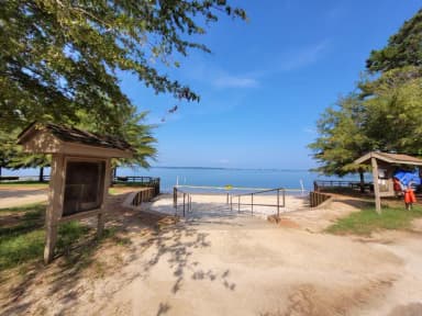
This site, photographed by the agency
Photos: Recreation.gov RIDB media records filed against this campsite · Oct 19, 2026
Filed by the agency against this site and 6 other campsites here
Shared frame: SHA-256 of the agency’s own file, compared across every campsite photograph at this campground · Sep 12, 2026
Group Shelter NonelectricType
Reservablerecreation.gov lists it
87 ftRoom
340 ftElevation
0%Tree cover
41 ftWater · to J. Strom Thurmond Reservoir
682 ftNearest toilet · OpenStreetMap
The agency files this record as day use, not as a place to spend the night. It’s on this site because the agency files it against this campground, not because it’s somewhere to camp.
Elevation: USGS 3DEP elevation point query at this site’s coordinate · Sep 7, 2026
Tree cover: NLCD Tree Canopy Cover 2024 (USDA Forest Service / MRLC), one 30 m cell at this coordinate · Sep 9, 2026
Room
87 ftto the nearest other site, against 62 ft typical here
#4 of 10roomiest site in the campground
1other site within 100 ft
No RV or electric sites within 100 ftso, probably no generators
The site
TypeGroup Shelter Nonelectric
LoopELIJAH MINI SHELTER
HookupsNone
Driveway SurfacePaved
Capacity/Size RatingSingle
Max Num of People6
Max Num of Vehicles1
ShadeYes
Pets AllowedYes
Checkin Time8:00 AM
Checkout Time8:30 PM
Min Num of People1
AccessibleNot listed
Source: Recreation.gov RIDB full extract, per-site record · Oct 19, 2026
Not a place to sleep
The agency files this record as day use, not as a place to spend the night.
Source: Recreation.gov
The campground
Every site, the season, fees, weather, and what’s happening on this land right now: Clarks Hill →
Most private sites here02 569 ft01 511 ft03 511 ft1 87 ft2 87 ft
Source: CAMPANAC campground index
