Rombo
1Heads up1 fire 28 mi away
- Right now
- Closedrecreation.gov lists every site closed this weekend, read 16:37 UTC
- A night
- $15When it reopens, per site
- Sites
- 16In the agency’s record
The place
the agency’s own description · what’s there · 9 notices
In the agency’s own words
Rombo Campground is located in a scenic area along the West Fork Bitterroot River in the mountains of southwestern Montana. The area is home to a variety of big game and wildlife, and provides access to a number of outdoor activities, including fishing, seasonal rafting and various hiking trail opportunities. Keep reading
Recreation
Fly fishing and wading in the West Fork Bitterroot River are popular activities. During high water season, kayaking and rafting are available as well. Painted Rocks Lake is just five miles south of the campground. Visitors enjoy swimming, kayaking, boating and fishing. Anglers will find mountain whitefish and a variety of trout. Many trails and unimproved roads in the area are great for exploring by bike or off-road vehicle. Hiking trails to various mountain peaks are nearby.
Facilities
The campground offers 16 sites, four of which are accessible, for tent and RV camping. Individual sites can accommodate up to 10 people and two vehicles. One bear proof container is provided for tent campers on bicycles or ATVs to comply with the Food Storage Order. Bear proof garbage dumpsters are available throughout the campground. Picnic tables, campfire rings and grills are provided, as are accessible pit toilets and drinking water. A campground host is on-site. Utility hookups are not available. Parking surfaces are gravel. A fill site for potable water is located just beyond Site #16 Natural Features The campground is located along the West Fork of the Bitterroot River. Large yellow-barked ponderosa pine trees tower above many of the campsites, which along with fir, aspen and cottonwoods, provide pleasant shade. The campground is situated at an elevation of 4,500 feet. A variety of wildlife makes its home in the area, including bald eagles, piliated woodpeckers, mule and white-tailed deer, moose, elk, bighorn sheep, black bears and numerous songbirds.
Nearby Attractions
The Alta Ranger Station, located on Hughes Creek Road, was the first Forest Service Ranger Station in the United States, built in 1899. It remains a popular tourist location and is a short distance from the campground. Horse Creek Hot Springs is about 29 miles from the campground and can be accessed via a gravel road with a high-clearance vehicle. A post office and a general store and deli can be found in Conner, 16 miles from the campground. Darby is 24 miles from the campground. It is a full-service community with fuel, lodging, a grocery store, restaurants, and other local businesses.
Charges & Cancellations
A $10.00 service fee will apply if you change or cancel your reservation. Late cancellations are subject to additional fees. For full details see NRRS Reservation Policy.
What the agency tells you
Camping is permitted during the off-season but water is not available
Call (406) 821-3269 for information on potential road closures or fire restrictions
Click here for more information on the Bitterroot National Forest
Everything else this campground posts · 6
Check out the forest's campground description for specific information to Fish Your National Forest
Don't Move Firewood: Prevent the spread of tree-killing pests by obtaining firewood near your destination and burning it on-site. For more information visit dontmovefirewood.org.
There is no cell phone coverage in this campground.
Bears frequent the area. Food Storage requirements are in effect on all National Forest System lands within the Montana portion of the Bitterroot National Forest from March 1 - December 1 annually.
For additional information on the Food Storage visit https://nfs.fs2c.usda.gov/sites/nfs/files/r01/bitterroot/publication/alerts/BRF_FSO_Handout_final.pdf
Shoreline stabilization project was completed on the West Fork Bitterroot River, along the Rombo Campground in the fall of 2025.
Tents and rigs
- Sites
- 16
- Hookups
- None
- Longest rig
- 65 ft
- Accessible sites
- 3
- Shade
- Every site
Facilities
- Toilets
- Pit Toilets
- “…grills are provided, as are accessible pit toilets and drinking water. A campground host is on-site.…”
- Drinking water
- Yes
- “…as are accessible pit toilets and drinking water. A campground host is on-site. Utility hookups are…”
- Store
- Nearby
- Bear boxes
- Yes
- Camp host
- On site
- recreation.gov lists “Host”
Around the campground
- On the water
- Hot springs, Lake, River, Creek
- Biking
- Boating
- Fishing
- Hiking
- Historic site
- Water sports
- Wildlife viewing
- Night sky · 63rd darkest of 501 in MT
- Bortle 2
Nothing to book until it reopensread 16:37 UTC
recreation.gov lists every site closed this weekend
Every one of the next thirty nights is in recreation.gov’s record and not one site is being offered on any of them. That’s a campground closed or not yet released for booking, not a sold-out one.
Tell me when it reopens
Watch for it to come back
One email when the agency reopens it, plus More Than Just Parks dispatches. Unsubscribe any time.
We check the agency’s own record once an hour, at 40 minutes past, and write the first time it stops saying closed.
Scanners that check every few minutes exist, and most of them charge. This one is free, it reads the same calendar, and it won’t always be first.
Every line of the receipt · 11
What you actually pay
“A $10.00 service fee will apply if you change or cancel your reservation.” · this campground’s own terms
Who keeps the booking fee
The agency’s own policy text says the reservation fee and the cancellation processing fee are “retained by the reservation service contractor”, and that a campground concessionaire will decline to refund them because “they did not receive these fees”. Recreation.gov is run under contract by Booz Allen Hamilton. What share of your booking fee the contractor keeps isn’t published in any federal dataset we can read, so we print no number for it. Our reporting on the contract →
How we know this receipt · 5
Why this page can’t say why
recreation.gov lists every site at Rombo closed this Friday and Saturday night. The U.S. Forest Service has published no closure notice we hold, so this page can’t say why, and it won’t fill the gap with a guess. A closed night isn’t a sold-out one: the reservations its record still carries were taken before the sites were closed.
There’s no notice to quote and no reason to argue with, so this page offers you the watch and the list below, and no letter.
Open within 60 miles · 4
The agency’s own word that these are open, not our reading of a season.
- Poet Creek CampgroundNezperce National Forest · 37 mi · walk-up
- Granite Springs CampgroundNezperce National Forest · 40 mi · walk-up
- Bridge Creek CampgroundNezperce National Forest · 45 mi · walk-up
- Red River CampgroundNezperce National Forest · 48 mi · walk-up
recreation.gov availability, read 16:37 UTC · rules read Sep 9, 2026 · rates Sep 10, 2026 · How we know all this
The sites
16 sites · which ones have room · the site map
The sites, ranked
from 13 mapped sitesAll 16 sites
The price is derived by CAMPANAC, not published per site: the per-night rate this campground publishes for each site’s own site type. 16 of the 16 sites listed carry one, and a site whose type has no published rate sits out of the price rather than being called free.
| AREA ROMBO | 01 | standard nonelectric | 40 ft | $15 | |||
| AREA ROMBO | 02 | standard nonelectric | 40 ft | $15 | |||
| AREA ROMBO | 03 | standard nonelectric | 32 ft | 224 ft | 348 ft | $15 | |
| AREA ROMBO | 04 | standard nonelectric | 30 ft | 94 ft | 186 ft | $15 | |
| AREA ROMBO | 05 | standard nonelectric | 40 ft | 94 ft | 166 ft | $15 | |
| AREA ROMBO | 06 | standard nonelectric | 33 ft | $15 | |||
| AREA ROMBO | 07 | standard nonelectric | 65 ft | 101 ft | 379 ft | $15 | |
| AREA ROMBO | 08 | standard nonelectric | 50 ft | 101 ft | 303 ft | $15 | |
| AREA ROMBO | 09 | standard nonelectric | 40 ft | 82 ft | 366 ft | $15 | |
| AREA ROMBO | 10 | standard nonelectric | 50 ft | 82 ft | 285 ft | $15 | |
| AREA ROMBO | 11 | standard nonelectric | 55 ft | 86 ft | 371 ft | $15 | |
| AREA ROMBO | 12 | standard nonelectric | 65 ft | 86 ft | 286 ft | $15 | |
| AREA ROMBO | 13 | standard nonelectric | 50 ft | yes | 89 ft | 295 ft | $15 |
| AREA ROMBO | 14 | standard nonelectric | 45 ft | yes | 161 ft | 415 ft | $15 |
| AREA ROMBO | 15 | standard nonelectric | 60 ft | yes | 109 ft | 604 ft | $15 |
| AREA ROMBO | 16 | standard nonelectric | 45 ft | 109 ft | 629 ft | $15 |
OpenStreetMap has no toilet mapped within 1 km of this campground, so no site here carries a toilet distance. That’s a gap in the map, not a finding about the campground.
Getting there
the map and the coordinate · the agency’s directions · the phone number
Where it is
 Sam Billings Memorial CampgroundBitterroot National Forest · 4.4 mi
 Slate Creek CampgroundBitterroot National Forest · 4.6 mi
 Fales Flat CampgroundBitterroot National Forest · 8.0 mi
 Medicine Point LookoutBitterroot National Forest · 8.7 mi
 Alta CampgroundBitterroot National Forest · 9.8 miLost Spring CampgroundBitterroot National Forest · 11 mi
From Darby, Montana drive south on Highway 93 approximately 4 miles to Road 473. Turn right and head southwest continue approximately 18 miles to the campground, which is on the right.
The weather
the next four days · the thirty-year normal
Next four days, and the thirty-year normal
Forecast
NWS forecast for Conner, MT
Typical weather
Typical October night 27°F, day 58°F.
Coldest month of the year: typical December night 12°F, below freezing. Bring a bag rated colder than that, and expect ice in the water bottle.
Daily high and lowDays with 0.10 in or more
A normal is the 1991-2020 average for the month, not a forecast: about half of all Julys are colder than the July line. The seven-day forecast above answers the other question.
The land, and who answers for it
what threatens it · who answers for it
What threatens this place
You’re camping on ground somebody wants. We track the threats and the comment deadlines.
Who answers for this land
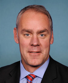
Rombo is in Montana’s 1st congressional district. Its representative, Ryan Zinke (R), votes on the laws that decide what happens to this land. Public-lands grade so far: F. See every public-lands vote →