Twogood Cabin
2Heads up2 fires, nearest 28 mi
- Right now
- Closedrecreation.gov lists every site closed this weekend, read 15:15 UTC
- Sites
- 1In the agency’s record
The place
the agency’s own description · what’s there · 12 notices
In the agency’s own words
Twogood Cabin offers guests a unique opportunity to camp in the forest of western Montana, in a rustic, old-time setting. It is available between the end of May through the middle of October, as well as throughout December, providing access to the surrounding mountains' best features and recreational attractions. Hiking, backpacking and horseback riding is popular during the warmer months and visitors enjoy cross country skiing and snowshoeing on the snow-covered terrain. Twogood Cabin is located 6 miles up a non-motorized trail. Keep reading
Recreation
Fishing is popular in the adjacent stream and anglers might catch a variety of trout. At least two other mountain creeks are available in the area. The Warm Springs Creek is a larger stream and provides excellent fishing for cutthroat and other trout. Visitors also enjoy wading in the cool water. A variety of hiking, mountain biking and horseback riding trails follow the creek. The large, rolling meadows are a winter elk range. When the snow melts, moose and deer may be spotted in the meadows. The 6-mile hike includes several creek crossings. Off-road vehicles are not allowed on the trail, however, horses and other livestock are welcome. In the winter, the trails are popular for cross country skiing and snowshoeing.
Facilities
The one-room cabin measures 15x19 feet with a concrete floor and covered porch. It accommodates up to four people and is equipped with two bunk beds, a table and chairs, counter space, a wood stove for heat and a two burner propane stove for cooking. A propane lantern is also available. Guests will need to bring your own propane fuel canisters. There is a wood stove for heat. Firewood is usually available under the covered porch outside the cabin but you may need to split your own logs. Inside the cabin pots, pans, and basic cooking and eating utensils are available. An outdoor outhouse serves the cabin but you will need to provide your own toilet paper . Porcupine Creek is the sole source of drinking water for you and your stock. It is recommended you use a water purifier, boil, or otherwise treat the water before consuming. You will need to provide your own bedding and towels . Guests are required to clean the cabin prior to their departure . Three hitch rails for stock are located within site of the cabin and can accommodate up to 12 head of stock. An area behind the cabin is often used to high-line stock overnight. Grazing within one mile of the cabin is prohibited. Feed for stock must be certified weed-seed free. Access to Twogood Cabin is by forest road and trail. Winter conditions can prevent access by vehicle to the trailhead. Snowshoeing, cross country skiing or snowmobiling may be the only access to the trailhead in the winter time. Guests are responsible for their own travel arrangements and safety, and must bring several of their own amenities.
Natural Features
The rustic cabin is situated on Porcupine Creek, in a road-less area of the southern Bitterroot Mountains, at an elevation of about 5,600 feet. It was built in 1952 by Harry Twogood and Clifford Wetzsteon and was used throughout the 1970s as a range camp until it was opened to the public for recreation purposes. The Bitterroot forest is home to many species of wildlife, from mule deer, whitetail deer, elk, bighorn sheep, mountain goats, black bear, mountain lions, and moose to many varieties of smaller animals and birds. Contact Info For facility specific information, please call (406) 821-3913.
Nearby Attractions
Overwhich Falls
What the agency tells you
Drinking water is not available. Nearby water sources must be filtered, boiled, or otherwise treated prior to consumstion.
Guests must provide their own propane fuel for cooking and lighting
This facility is located in a remote area; before making a reservation, become aware of bear, water and weather safety
Everything else this campground posts · 9
All garbage and food must be packed out. Do not leave anything you bring, even if you think it will benefit other renters.
You will need to provide your own bedding and towels.
Feed brought in for livestock must be certified weed-free
Learn more about the Bitterroot National Forest
Don't Move Firewood: Prevent the spread of tree-killing pests by obtaining firewood near your destination and burning it on-site. For more information visit dontmovefirewood.org.
During the winter, the road to the trailhead may not be accessible by vehicle and other means of transportation, such as skiing, snowshoeing, or snowmobile, may be needed to reach the trailhead
Some cleaning supplies are provided but you should plan to bring your own in case they are not available during your stay. Please help keep the cabin clean
Check in time is 2:00 PM; Check out time is 12:00 PM
The cabin remains locked; a week before your scheduled arrival, contact the Darby-Sula Ranger District at 406-821-3913 during office hours (Mon-Fri 8:00 a.m. - 4:30 p.m.) to obtain a key code, road and trail conditions, and weather report.
Tents and rigs
- Sites
- 1 · 1 cabin
- Hookups
- None
- Accessible sites
- None listed
Facilities
- Toilets
- Yes, the record doesn't say what kind
- OUTHOUSE on 1 of 1 campsite records
- Drinking water
- Yes
- “…. Porcupine Creek is the sole source of drinking water for you and your stock. It is recommended you use a…”
- Firewood
- Mentioned
Around the campground
- On the water
- Creek, Meadow
- Backpacking
- Fishing
- Hiking
- Horseback riding
- Mountain biking
- Wildlife viewing
- Winter sports
Nothing to book until it reopensread 15:15 UTC
recreation.gov lists every site closed this weekend
Every one of the next thirty nights is in recreation.gov’s record and not one site is being offered on any of them. That’s a campground closed or not yet released for booking, not a sold-out one.
Tell me when it reopens
Watch for it to come back
One email when the agency reopens it, plus More Than Just Parks dispatches. Unsubscribe any time.
We check the agency’s own record once an hour, at 40 minutes past, and write the first time it stops saying closed.
Scanners that check every few minutes exist, and most of them charge. This one is free, it reads the same calendar, and it won’t always be first.
Every line of the receipt · 11
What you actually pay
Who keeps the booking fee
The agency’s own policy text says the reservation fee and the cancellation processing fee are “retained by the reservation service contractor”, and that a campground concessionaire will decline to refund them because “they did not receive these fees”. Recreation.gov is run under contract by Booz Allen Hamilton. What share of your booking fee the contractor keeps isn’t published in any federal dataset we can read, so we print no number for it. Our reporting on the contract →
How we know this receipt · 4
Why this page can’t say why
recreation.gov lists every site at Twogood Cabin closed this Friday and Saturday night. The U.S. Forest Service has published no closure notice we hold, so this page can’t say why, and it won’t fill the gap with a guess. A closed night isn’t a sold-out one: the reservations its record still carries were taken before the sites were closed.
There’s no notice to quote and no reason to argue with, so this page offers you the watch and the list below, and no letter.
Open within 60 miles · 4
The agency’s own word that these are open, not our reading of a season.
- Poet Creek CampgroundNezperce National Forest · 48 mi · walk-up
- Granite Springs CampgroundNezperce National Forest · 51 mi · walk-up
- Bridge Creek CampgroundNezperce National Forest · 57 mi · walk-up
- Red River CampgroundNezperce National Forest · 59 mi · walk-up
recreation.gov availability, read 15:15 UTC · rules read Sep 9, 2026 · rates Sep 10, 2026 · How we know all this
The sites
1 sites · the site map
All 1 sites
Toilet distances are OpenStreetMap’s, measured for 1 of the 1 sites listed. A site with no reading is unknown, never far.
The price is derived by CAMPANAC, not published per site: the per-night rate this campground publishes for each site’s own site type. 1 of the 1 sites listed carry one, and a site whose type has no published rate sits out of the price rather than being called free.
| AREA TWOGOOD CABIN | 01 | cabin nonelectric | 59 ft | 163 ft | $30 |
Getting there
the map and the coordinate · the agency’s directions · the phone number
Where it is
 Crazy Creek CampgroundBitterroot National Forest · 3.9 mi
 Indian Trees CampgroundBitterroot National Forest · 4.4 mi
 Medicine Point LookoutBitterroot National Forest · 4.7 miWarm Springs CampgroundBitterroot National Forest · 5.8 mi
 Gordon Reese CabinBeaverhead National Forest · 6.9 mi
 Spring GulchBitterroot National Forest · 7.0 mi
From Missoula, Montana, travel south on Highway 93 to Medicine Creek Road/Forest Service Road 370, which is approximately 36 miles south of Hamilton. Turn right and continue about 4 miles to the trailhead, which is located at Crazy Creek Campground. An easy, 6-mile hike leads to the cabin from the parking area.
The trail follows Warm Springs Creek until it intersects with two other creeks, and then follows Porcupine Creek about a mile to the cabin. Trails are open to hiking, horseback riding, mountain biking. Off-road vehicles are not allowed.
The weather
the thirty-year normal
Next four days, and the thirty-year normal
Typical weather
Typical October night 26°F, day 54°F.
Coldest month of the year: typical December night 10°F, below freezing. Bring a bag rated colder than that, and expect ice in the water bottle.
Daily high and lowDays with 0.10 in or more
A normal is the 1991-2020 average for the month, not a forecast: about half of all Julys are colder than the July line. The seven-day forecast above answers the other question.
The land, and who answers for it
what threatens it · who answers for it
What threatens this place
You’re camping on ground somebody wants. We track the threats and the comment deadlines.
Who answers for this land
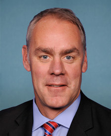
Twogood Cabin is in Montana’s 1st congressional district. Its representative, Ryan Zinke (R), votes on the laws that decide what happens to this land. Public-lands grade so far: F. See every public-lands vote →