Walker Pass Campground
1Heads up1 fire 22 mi away
This is how it should work.
- Right now
- Nobody has saidNo season, no closure, no bookings to read
The place
the agency’s own description · what’s there
In the agency’s own words
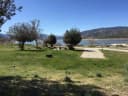
Walker Pass Campround is located just off of California State Highway 178 and at the junction of the Owens Peak and Cache Peak segments of the Pacific Crest National Scenic Trail. Located at 5,000 feet, there are pinyon pines and a few Joshua trees in this semi-arid setting and outstanding views of the dry, rugged foothills of the Southern Sierras. The campround includes eleven walk in sites for Pacific Crest Trail hikers and tent campers. The camprgound also has two sites for car camping. All sites have a picnic table and fire ring. Hitching racks and corrals are available for horses. No potable water is available at this site.
Facilities
- Drinking water
- None, bring your own
- “…and corrals are available for horses. No potable water is available at this site.”
Around the campground
- Hiking
- Horseback riding
- Wildlife viewing
Nothing to book, just show up
One of 1,623 federal campgrounds where the site still goes to whoever pulls in first. Get there before noon on a summer weekend.
recreation.gov publishes no availability for a campground you can’t reserve, so there’s no thirty-night reading to draw here. The season bar above is what the agency does publish.
Every line of the receipt · 3
What you actually pay
How we know this receipt · 4
rules read Sep 7, 2026 · record Aug 23, 2026 · How we know all this
Getting there
the map and the coordinate · the phone number
Where it is


The weather
the next four days
Next four days, and the thirty-year normal
Forecast
NWS forecast for Onyx, CA
The land, and who answers for it
what threatens it · who answers for it
Roadless country, and what’s coming for it
You’re camping on ground somebody wants. We track the threats and the comment deadlines.
Who answers for this land

Walker Pass Campground is in California’s 20th congressional district. Its representative, Vince Fong (R), votes on the laws that decide what happens to this land. Public-lands grade so far: F. See every public-lands vote →