National Park Service · National Park · Alaska
Kenai Fjords National Park
Here, all of the campgrounds take walk-ups.
1Campgrounds
1Take walk-ups
1Free to camp
12Sites
350 ftElevation
Where they are
1 of 1 mappedDrawing the map
© OpenFreeMap · OpenStreetMap · Esri hillshadeSource: RIDB · NPS · USFS EDW · BLM, unified by CAMPANAC · Sep 9, 2026
The campgrounds
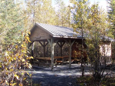
Source: RIDB · NPS · USFS EDW · BLM, unified by CAMPANAC · Sep 9, 2026
This land
measured from the nearest campground in the unitRoadless
Camping here is a stake in what happens to it. More Than Just Parks tracks the threats and the comment windows.
Source: USFS Inventoried Roadless Areas via MTJP Roadless Map · Jul 29, 2026
Heads up
Caution
Use Caution in and around Pedersen Lagoon On August 7, 2024, a landslide triggered tsunami washed over portions of Pedersen Lagoon near Aialik Bay (59.8842N, -149.7309W). We recommend caution for those visiting the area in and around Pedersen Lagoon. Click more for additional…
Danger
Hazardous Conditions at Terminus Of Aialik Glacier Entering an ice fall hazard zone is prohibited in Kenai Fjords National Park. The terminus of Aialik Glacier is a high-risk area, where unstable ice can fall in blocks or columns. This can generate localized tsunami waves that wash over…
Danger
Canyon from Toe of Exit Glacier to the Outwash Plain The canyon from the toe of Exit Glacier to where Exit Creek opens into the Outwash Plain is susceptible to sudden outburst flood events. These events produce sudden surges of water, ice and rock. For your safety please stick to designated…
Source: National Park Service alerts API · Oct 24, 2026
Who answers for this land
Kenai Fjords National Park’s campgrounds sit in one congressional district. These members vote on the laws that decide what happens to this land.

Nick Begich (R)
Source: campground records from RIDB, NPS, USFS EDW and BLM, unified by CAMPANAC, refreshed nightly