National Park Service · National Park · North Dakota
Theodore Roosevelt National Park
Here, none of the campgrounds take walk-ups.
5Campgrounds
$10A night at all 2 priced
123Sites
1,960–2,370 ftElevation
Where they are
5 of 5 mappedDrawing the map
© OpenFreeMap · OpenStreetMap · Esri hillshadeSource: RIDB · NPS · USFS EDW · BLM, unified by CAMPANAC · Oct 23, 2026
The campgrounds
5 campgrounds
 Cottonwood Campground (ND)ReservableOpenfrom $1012 walk-in sites6 hike-in sites72 sitesrigs to 68 ft2,250 ftdrinking watertoilets
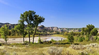 Juniper Campground (ND)ReservableOpenfrom $109 walk-in sites26 pull-through sites48 sitesrigs to 57 ft1,960 ftdrinking watertoilets
 Cottonwood Group Site (ND)ReservableSites from $601 pull-through site1 group site1 siterigs to 45 ft2,250 ftdrinking watertoilets
 Juniper Campground Group Site (ND)ReservableSites from $601 pull-through site1 group site1 site1,960 ftdrinking water
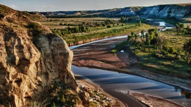 Roundup Group Horse CampReservableSites from $1001 pull-through site1 group site1 site2,370 ftdrinking watertoilets
Source: RIDB · NPS · USFS EDW · BLM, unified by CAMPANAC · Oct 23, 2026
This land
measured from the nearest campground in the unitRoadless
Roadless
Roadless
Roadless
Roadless
Roadless
Camping here is a stake in what happens to it. More Than Just Parks tracks the threats and the comment windows.
Source: USFS Inventoried Roadless Areas via MTJP Roadless Map · Jul 29, 2026
Heads up
Wildfire
Nuuba fire · 31 mi from the nearest campground here · 1 acres
Information
Theodore Roosevelt National Park moves to cashless fee collection Starting May 1, Theodore Roosevelt National Park will accept only credit cards, debit cards, or digital payments for entrance fees, campground fees, and Interagency Passes. Cash and check payments will no longer be accepted.
Information
South Unit Address for Mobile Maps – Theodore Roosevelt NP On all maps used on mobile devices, use the following address to reach the South Unit Visitor Center and Entrance Station 201 East River Road N. Medora, ND 58645
Information
Petrified Forest Trailhead Access Update: Use Approved Route Directions to the Petrified Forest trailhead have changed. Please use the approved legal route from I-94, Exit 10 toward Camels Hump Lake and follow the clearly marked posts. This update helps maintain good cooperation with neighbors and…
Alerts: National Park Service alerts API · Oct 24, 2026
Source: NIFC/IRWIN via MTJP wildfire tracker · Oct 23, 2026
Who answers for this land
Theodore Roosevelt National Park’s campgrounds sit in one congressional district. These members vote on the laws that decide what happens to this land.

Julie Fedorchak (R)
Source: campground records from RIDB, NPS, USFS EDW and BLM, unified by CAMPANAC, refreshed nightly