Beaver Creek Group Campground
2Heads up2 fires, nearest 37 mi
- Right now
- Closed for the seasonOut of the season the agency publishes
- Season
- May 1 – September 30Open May 1 through September 30
The place
the agency’s own description · what’s there
In the agency’s own words
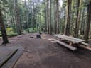
Beaver Creek campground is a popular group camp, situated along the south fork Stillaguamish River with a view of Big Four Mountain. The area is fairly flat making it an excellent site for small children. This campground can accommodate up to 25 people. In addition to fishing, there are opportunities nearby for hiking and bicycling.
Around the campground
- On the water
- River, Creek
Phone before you drive
recreation.gov publishes no availability for a campground you can’t reserve, so there’s no thirty-night reading to draw here. The season bar above is what the agency does publish.
Every line of the receipt · 4
What you actually pay
How we know this receipt · 4
record Aug 24, 2026 · How we know all this
Getting there
the map and the coordinate
Where it is
 Coal Creek Group CampgroundMt. Baker National Forest · 0.7 mi
 Coal Creek Group CampMt. Baker National Forest · 1.4 mi
 Tulalip Mill Site Group CampgroundMt. Baker National Forest · 4.9 mi
 Red Bridge CampgroundMt. Baker National Forest · 5.8 mi
 Bedal CampgroundMt. Baker National Forest · 6.6 mi
 Boardman Group CampMt. Baker National Forest · 7.0 mi
The weather
the next four days · the thirty-year normal
Next four days, and the thirty-year normal
Forecast
NWS forecast for Verlot, WA
Typical weather
Typical May night 44°F, day 66°F.
Coldest night of the open season: typical May night 44°F. Bring the bag rated for it.
Daily high and lowDays with 0.10 in or moreOutside the published season
A normal is the 1991-2020 average for the month, not a forecast: about half of all Augusts are colder than the August line. The seven-day forecast above answers the other question.
The land, and who answers for it
what threatens it · who answers for it
Roadless country, and what’s coming for it
You’re camping on ground somebody wants. We track the threats and the comment deadlines.
Who answers for this land

Beaver Creek Group Campground is in Washington’s 8th congressional district. Its representative, Kim Schrier (D), votes on the laws that decide what happens to this land. Public-lands grade so far: A+. See every public-lands vote →