Cougar Peak Lookout
1Heads up1 fire 38 mi away
- Right now
- Nobody has saidNo season, no closure, no bookings to read
- Sites
- 1All of them booked ahead
The place
the agency’s own description · what’s there · 8 notices
In the agency’s own words
The Cougar Peak Lookout offers guests an opportunity to experience an old-time Forest Service lookout. The tower commands an impressive view of the river valley, the surrounding Cabinet Mountains and the opposing Coeur d'Alene Mountains. The structure is small and is not elevated like many other lookouts. The lookout can be accessed by vehicle, although late spring snow drifts may compromise parts of the road, requiring visitors to hike a short distance. Guests are responsible for their own travel arrangements and safety, and must bring several of their own amenities. Keep reading
Recreation
A variety of trails and points of exploration are accessible from the lookout. The Cougar Peak Trail follows the ridge below the lookout and travels towards Vermillion Pass to the northeast. The Clark Fork River is dammed twice within an hour drive of the lookout. The Noxon Rapids and the Cabinet Gorge dams create reservoirs that have become popular spots for boating and fishing for large and smallmouth bass, as well as northern pike.
Facilities
The 14-by-14 structure is small, but can accommodate up to four people. There is a full bed for two with a mattress pad, a table with two chairs, and a wood stove. No other furnishings are provided. A rustic outhouse with a vault toilet is available about 200 feet from the lookout, at the parking area. Guests will need to bring water for drinking, cooking and cleaning purposes, as well as their own bedding and cots for additional sleeping options, cooking and eating equipment and fuel, cooking and eating utensils, flashlights, matches and toilet paper, among other necessities. There is no water available at the site. There is room for a small tent outside the tower. Guests should be prepared for cold and often wet or damp weather, even if the weather in the valley is warm and dry. Food, garbage and other waste needs to be put away at all times to avoid attracting bears. Firewood may be collected locally for the wood stove.
Natural Features
The tower is situated in the Clark Fork River drainage, at an elevation of 6,694 feet, in the Cabinet Mountains of western Montana. It was built in 1952 to replace an existing, older structure dating back to the 1930s. The lookout was part of the old Cabinet National Forest, which was divided by the Forest Service in 1954 to become the Lolo National Forest. The 2 million-acre forest includes four wilderness areas and a wide variety of trees, plants and wildlife. The area is home to mountain goats, bighorn sheep, elk, moose, deer and grizzly and black bears ( learn more about bear safety ). Both the bald and golden eagle reside in the forest, along with trumpeter swan, herons and dozens of varieties of ducks. Contact Info For facility specific information, please call (406) 210-5287.
What the agency tells you
Water is not available on-site.
Guests must hike 150 feet from the parking area to the lookout.
This facility is located in a remote area; before making a reservation, become aware of bear, water, and weather safety.
Everything else this campground posts · 5
All garbage, food and personal belongings must be packed out.
Learn more about the Lolo National Forest at: https://www.fs.usda.gov/lolo
Don't Move Firewood: Prevent the spread of tree-killing pests by obtaining firewood near your destination and burning it on-site. For more information visit dontmovefirewood.org.
The entry gate and lookout remains locked; a key code will be sent to you in your reservation confirmation.
Maximum stay limit is 3 nights per reservation.
Tents and rigs
- Sites
- 1 · 1 cabin
- Hookups
- None
- Longest rig
- 10 ft
- Accessible sites
- None listed
Facilities
- Toilets
- Vault Toilets
- “…are provided. A rustic outhouse with a vault toilet is available about 200 feet from the lookout, at…”
- Drinking water
- None, bring your own
- “…at the parking area. Guests will need to bring water for drinking, cooking and cleaning purposes, as…”
- Firewood
- Mentioned
Around the campground
- On the water
- River
- Biking
- Fishing
- Hiking
- Wildlife viewing
- Night sky · 272nd darkest of 501 in MT
- Bortle 2
No reading yet, book on recreation.gov
Every site here is reservable, and the record lists none held back for anyone who drives up.
No availability snapshot inside the last 36 hours, so this page draws nothing rather than ageing a reading into fiction.
Watch for a cancellation
Full? Watch it.
One email when a night opens, plus More Than Just Parks dispatches. Unsubscribe any time.
We read recreation.gov once an hour, at 40 minutes past, and write the first time a site in your window is free for the nights you asked for.
Scanners that check every few minutes exist, and most of them charge. This one is free, it reads the same calendar, and it won’t always be first.
Tell me when the season opens
Watch for the season to open
One email when the season goes on sale, plus More Than Just Parks dispatches. Unsubscribe any time.
We check once an hour, at 40 minutes past, and write the first time the agency has that season on sale.
Scanners that check every few minutes exist, and most of them charge. This one is free, it reads the same calendar, and it won’t always be first.
We make nothing when you book. The link goes straight to the government.
Every line of the receipt · 12
What you actually pay
Who keeps the booking fee
The agency’s own policy text says the reservation fee and the cancellation processing fee are “retained by the reservation service contractor”, and that a campground concessionaire will decline to refund them because “they did not receive these fees”. Recreation.gov is run under contract by Booz Allen Hamilton. What share of your booking fee the contractor keeps isn’t published in any federal dataset we can read, so we print no number for it. Our reporting on the contract →
How we know this receipt · 5
rules read Sep 9, 2026 · rates Oct 1, 2026 · How we know all this
The sites
1 sites · the site map
All 1 sites
Toilet distances are OpenStreetMap’s, measured for 1 of the 1 sites listed. A site with no reading is unknown, never far.
The price is derived by CAMPANAC, not published per site: the per-night rate this campground publishes for each site’s own site type. 1 of the 1 sites listed carry one, and a site whose type has no published rate sits out of the price rather than being called free.
| AREA COUGAR PEAK LOOKOUT | 001 | cabin nonelectric | 10 ft | 4,283 ft | 136 ft | $45 |
Getting there
the map and the coordinate · the agency’s directions · the phone number
Where it is
 Sex Peak. Lookout RentalKaniksu National Forest · 12 miClark Memorial CampgroundLolo National Forest · 13 miCopper King Campground13 mi
From Thompson Falls, Montana, travel west on Highway 200 for about a mile. Before crossing the Clark Fork River bridge, turn right onto Blue Slide Road and continue about 8 miles, to the junction with Forest Road 403. Turn right and travel about 14 miles to the lookout. Maps are available online or for purchase by calling the Plains/Thompson Falls Ranger District.
The weather
the next four days · the thirty-year normal
Next four days, and the thirty-year normal
Forecast
NWS forecast for Belknap, MT
Typical weather
Typical October night 32°F, day 44°F.
Coldest month of the year: typical December night 18°F, below freezing. Bring a bag rated colder than that, and expect ice in the water bottle.
Daily high and lowDays with 0.10 in or more
A normal is the 1991-2020 average for the month, not a forecast: about half of all Julys are colder than the July line. The seven-day forecast above answers the other question.
The land, and who answers for it
what threatens it · who answers for it
What threatens this place
You’re camping on ground somebody wants. We track the threats and the comment deadlines.
Who answers for this land
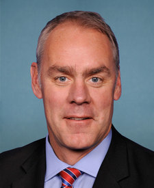
Cougar Peak Lookout is in Montana’s 1st congressional district. Its representative, Ryan Zinke (R), votes on the laws that decide what happens to this land. Public-lands grade so far: F. See every public-lands vote →