U.S. Forest Service · Uinta National Forest · UT

Balsam Campground

The agency doesn’t say how you get a siteIts record carries no access type, so treat it as a place to phone before you drive.
Right now
Listed not openA database flag with no reason and no date
Drawn from the record · 5,920 ft · 0% tree cover · Right Fork Hobble Creek within reach · Bortle 4 sky
5,920 ftElevation
273 ftWater · Right Fork Hobble Creek
8.1 miSE of Provo, UT
0%Tree cover
Bortle 4Night sky · 433rd darkest of 458 in UT

The place

the agency’s own description · what’s there

In the agency’s own words

Balsam Campground is located in Hobble Creek Canyon. Vegetation is fir, maple and cottonwood trees. Hobble Creek runs next to the campground. There are concrete pads under the tables. Popular activities include fishing Hobble Creek, playing volleyball or hiking Dry Canyon or Wardsworth Trail (both of which leave Hobble Creek Road within one mile of campground). Maple, fir and cottonwood trees forest the area, providing partial shade, beautiful fall color and some privacy between campsites. Hobble Creek runs through the campground.

Source: USFS Enterprise Data Warehouse · Aug 24, 2026

Around the campground

On the water
Creek
Fall color · reported 11 days ago, 7 km away
Past peak
Source: Stated in the agency description
Fall color: More Than Just Parks foliage tracker, joined to this campground by distance (7 km) · Oct 6, 2026

Phone before you drive

recreation.gov publishes no availability for a campground you can’t reserve, so there’s no thirty-night reading to draw here. The season bar above is what the agency does publish.

Booking window6 months outBooking opens 6 months ahead; today unlocks arrivals through April 16, 2027. The agency publishes no reservable season in the record we hold, so the window may close earlier than that.recreation.gov
Runs itU.S. Forest Servicethe agency’s record
Every line of the receipt · 3

What you actually pay

The sign priceU.S. Forest Service
The U.S. Forest Service publishes no per-night rate for this campground that we can read, so there’s no sign price to print. That’s a gap in the record, not a free campground.
The booking feerecreation.gov
We hold no recreation.gov booking record for this campground, so we can’t say whether a booking fee applies.
What a stay costs
The agency publishes no nightly rate for this campground, so there’s no total to show.
How we know this receipt · 4
Source: USFS Enterprise Data Warehouse · Aug 24, 2026

record Aug 24, 2026 · How we know all this

Seen something wrong here? Tell us.

Getting there

the map and the coordinate

The weather

the next four days · the thirty-year normal

Next four days, and the thirty-year normal

Forecast

Overnight38°Mostly Clear
Saturday64°Sunny
Saturday Night40°Mostly Clear
Sunday62°Partly Sunny4% rain

NWS forecast for Hobble Creek, UT

Typical weather

Typical October night 31°F, day 63°F.

Coldest month of the year: typical January night 13°F, below freezing. Bring a bag rated colder than that, and expect ice in the water bottle.

90°32°0°

Daily high and lowDays with 0.10 in or more

A normal is the 1991-2020 average for the month, not a forecast: about half of all Julys are colder than the July line. The seven-day forecast above answers the other question.

Measured at: DEER CREEK DAM, UT (USC00422057), 16 miles away and 650 ft lower

The land, and who answers for it

what threatens it · who answers for it

Roadless country, and what’s coming for it

Roadless
Wardsworth Peak25,758 acres · 3 mi · inventoried roadless area
Roadless
Mollies Nipple32,698 acres · 4 mi · inventoried roadless area
Roadless
Red Mountain9,683 acres · 5 mi · inventoried roadless area

You’re camping on ground somebody wants. We track the threats and the comment deadlines.

Who answers for this land
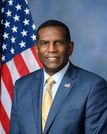
Burgess Owens, official portrait

Balsam Campground is in Utah’s 4th congressional district. Its representative, Burgess Owens (R), votes on the laws that decide what happens to this land. Public-lands grade so far: F. See every public-lands vote →

Seen something wrong here? Tell us.

How we know

every fact on this page, and where it came from
Right now: U.S. Forest Service’s own recreation database flags it not open and publishes no reason and no date. That’s a flag, not a notice.
Fall color: More Than Just Parks foliage tracker, joined to this campground by distance (7 km) · Oct 6, 2026
Cell signal: the Forest Service’s own campground description, read as text by CAMPANAC. None of this is a measurement. It’s what the land manager published about the place, and phones, carriers and weather all disagree with each other; treat it as a warning, not a promise.
Nearest place of any size: Hobble Creek, UT, 3.9 mi E (a census designated place). Straight line.