Digit Point Campground
1Heads up1 fire 45 mi away
This is how it should work.
- Right now
- Listed not openA database flag with no reason and no date
- A night
- $12From, per site
The place
the agency’s own description · what’s there
In the agency’s own words
For outdoor enthusiasts looking for a campground in a peaceful forest setting with great fishing and a variety of hiking opportunities, Digit Point Campground is the place. This scenic campground is located on the south shore of Miller Lake 35 minutes west of Chemult, Oregon. The location of the campground places many campsites on the lake shore with scenic views of the lake and Mt. Thiels­en. A dense growth of mixed conifers including hemlock, white pine, white fir and sugar pine, provide ample shade. Osprey, eagles, loons and grebes are local residents. Keep reading
June and July are heavy mosquito months, so bring bug spray. The best part about camping at Digit Point is that it offers a full array of ac­tivities including biking boating, fishing, hiking and swimming. Miller Lake's brown, rainbow and brook trout and Kokanee salmon pose a challenge for anglers of any age. A person can also fish 24 hours a day here. The Miller Lake Trail loop provides hikers an opportunity to explore part of Mt. Thielsen Wilderness and be back at camp for dinner. This five-mile loop trail also allows hikers to access the Pacific Crest National Scenic Trail and Maidu Trail . Amenities include picnic tables, potable water, campfire rings, three flush toilets, one vault toilet and an RV dump station.
Facilities
- Toilets
- Flush Toilets · Vault Toilets
- “…potable water, campfire rings, three flush toilets, one vault toilet and an RV dump station.”
- Drinking water
- Yes
- “…Trail . Amenities include picnic tables, potable water, campfire rings, three flush toilets, one vault…”
- Dump station
- Yes
Around the campground
- On the water
- Lake
Nothing to book, just show up
One of 1,623 federal campgrounds where the site still goes to whoever pulls in first, and a night costs $12 with nothing added. Get there before noon on a summer weekend.
recreation.gov publishes no availability for a campground you can’t reserve, so there’s no thirty-night reading to draw here. The season bar above is what the agency does publish.
Every line of the receipt · 5
What you actually pay
“$12/Night for single unit, $5/Night for extra vehicle” · the U.S. Forest Service’s own fee record
Derived by CAMPANAC: the lowest per-night amount the agency’s fee record states ($12), and no booking fee, because this campground takes no reservations. A weekend here means Friday and Saturday night. Optional charges (an extra vehicle, a second tent, a dump-station fee) are listed separately and aren’t in this total.
How we know this receipt · 6
record Aug 24, 2026 · How we know all this
Getting there
the map and the coordinate
Where it is
 Kelsay Valley Horse CampUmpqua National Forest · 9.1 miDiamond Lake ResortUmpqua National Forest · 9.3 mi
 Diamond LakeUmpqua National Forest · 9.6 miDiamond Lake RV ParkUmpqua National Forest · 10 mi
 Thielsen View CampgroundUmpqua National Forest · 11 mi
 Inlet CampgroundUmpqua National Forest · 11 mi
The weather
the next four days · the thirty-year normal
Next four days, and the thirty-year normal
Forecast
NWS forecast for Chemult, OR
Typical weather
Typical October night 24°F, day 61°F.
Coldest month of the year: typical December night 15°F, below freezing. Bring a bag rated colder than that, and expect ice in the water bottle.
Daily high and lowDays with 0.10 in or more
A normal is the 1991-2020 average for the month, not a forecast: about half of all Julys are colder than the July line. The seven-day forecast above answers the other question.
The land, and who answers for it
what threatens it · who answers for it
Roadless country, and what’s coming for it
You’re camping on ground somebody wants. We track the threats and the comment deadlines.
Who answers for this land
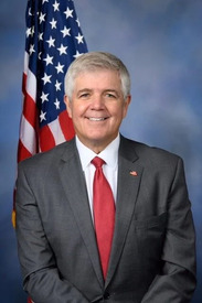
Digit Point Campground is in Oregon’s 2nd congressional district. Its representative, Cliff Bentz (R), votes on the laws that decide what happens to this land. Public-lands grade so far: F. See every public-lands vote →