Marion Forks Campground and Day Use Area
3Heads up3 fires, nearest 12 mi
This is how it should work.
- Right now
- OpenThe agency lists it open
- Season
- Year-roundOpen year-round
The place
the agency’s own description · what’s there
In the agency’s own words
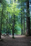
Adjacent to the Marion Forks Fish Hatchery , Marion Forks Campground is a great 15 site (one pull through) campground tucked away from Highway 22 and a quiet place to relax. Enjoy a 1/4 mile leisurely stroll along Marion Creek on a paved loop path through the picnic area and fish hatchery and learn about spring Chinook salmon and the history of the area. Nearby, on Forest Service Road 2255, you can find the little used trail (#3431) to Independence Rock for a short hike. If you drive further up to the end of Road 2255, you'll reach the trailhead to Marion Lake (Trail #3436) leading to the Mt. Jefferson Wilderness.
Around the campground
- On the water
- Lake, Creek
Nothing to book, just show up
One of 1,623 federal campgrounds where the site still goes to whoever pulls in first. Get there before noon on a summer weekend.
recreation.gov publishes no availability for a campground you can’t reserve, so there’s no thirty-night reading to draw here. The season bar above is what the agency does publish.
Every line of the receipt · 4
What you actually pay
“Single Campsites - $21 per night Multiple Campsites - $40 per night Extra Vehicles - $7 per vehicle, per night Download the Recreation.gov mobile app prior to your trip so you can pay the overnight fee digitally onsit…” · the U.S. Forest Service’s own fee record
How we know this receipt · 5
record Aug 24, 2026 · How we know all this
Getting there
the map and the coordinate
Where it is
 RIVERSIDE AT DETROIT (Willamette National Forest, OR)Willamette National Forest · 2.1 mi
 Whispering Falls CampgroundWillamette National Forest · 6.1 mi
 Big Meadows Horse CampWillamette National Forest · 8.4 miBig PoolWillamette National Forest · 8.4 mi
 Santiam Flats Campground11 mi
The weather
the next four days · the thirty-year normal
Next four days, and the thirty-year normal
Forecast
NWS forecast for Idanha, OR
Typical weather
Typical October night 35°F, day 60°F.
Coldest month of the year: typical January night 27°F, below freezing. Bring a bag rated colder than that, and expect ice in the water bottle.
Daily high and lowDays with 0.10 in or more
A normal is the 1991-2020 average for the month, not a forecast: about half of all Julys are colder than the July line. The seven-day forecast above answers the other question.
The land, and who answers for it
what threatens it · who answers for it
Roadless country, and what’s coming for it
You’re camping on ground somebody wants. We track the threats and the comment deadlines.
Who answers for this land

Marion Forks Campground and Day Use Area is in Oregon’s 5th congressional district. Its representative, Janelle Bynum (D), votes on the laws that decide what happens to this land. Public-lands grade so far: A+. See every public-lands vote →